
Upper Missouri Basin
Introduction
The Upper Missouri Basin extends from its vast headwaters in the mountains of Montana and Wyoming, across those two states, the Dakotas, and Nebraska, to the confluence of the Missouri and Platte Rivers near Omaha. (The Platte River Basin, which is a subbasin of the Upper Missouri basin, is given its own page in TreeFlow because of the number of reconstructions in that subbasin.)
As one moves north along the eastern slope of the Rockies into Wyoming and Montana, trees tend to be less moisture-sensitive than to the south. This makes the development hydroclimatic reconstruction more challenging, although robust reconstructions of annual streamflow are still feasible. While there are no streamflow reconstructions for the mainstem upper Missouri, reconstructions of headwaters rivers in the southwestern part of the basin have recently been developed (see map and list below). There is good potential for additional streamflow reconstructions.
In 2003, Graumlich et al, published a reconstruction of annual streamflow for the Yellowstone River at Corwin Spring, MT. The reconstruction model uses as predictors tree-ring reconstructions of the SOI (Southern Oscillation Index) and PDO (Pacific Decadal Oscillation). While SOI and PDO are linked to hydroclimatic variability in the upper Missouri Basin, it is not clear that these teleconnections are stable over long time frames, so the Graumlich et al. reconstruction should be considered an experimental work. Reconstructions for the Missouri basin are currently being developed as part of an project funded by the National Science Foundation. For more information see: http://www.nrmsc.usgs.gov/MissouriRiverWater
The map below shows the streamflow reconstructions currently available for the Upper Missouri Basin. Place the cursor on a gage icon to view the gage name, and then click to view the page for that reconstruction, and a link to the data. A list of the reconstructions available for the basin is presented below the map.
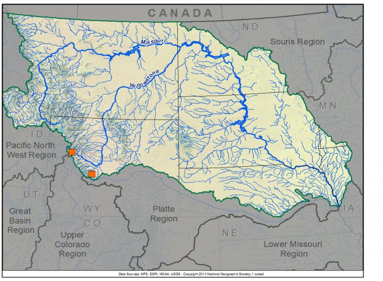
Upper Missouri Basin Reconstructions
| Streamflow Reconstruction Page | Period | Data File |
| Wind River near Dubois, WY | 1560-1992 | winddubois.txt |
| Little Popo Agie R. near Lander, WY | 1560-1999 | littlepopoagie.txt |
Other Hydroclimatic Reconstructions developed for, or including, the Upper Missouri Basin:
Bighorn Basin (MT-WY) annual precipitation, 1260-1998 - Gray et al. 2004.
Glacier National Park (MT) Summer Drought (P-PET), 1540-2000 - Pederson et al. 2006
Summer (JJA) Palmer Drought Severity Index (PDSI), covering most of North America on 2.5-degree grid
 presents \"Tree-Ring 101\" at the Boulder City, NV workshop.")
While none of technical workshops for water managers and stakeholders have been held within the Upper Missouri Basin, many of the presentations on data and applications are still relevant to that basin. Click on a workshop below to access a summary report and the presentations; see the Treeflow Workshops page for general information about the workshops.

There are many different ways to use tree-ring reconstructions in the planning and management for water resources, from educational tools to inform stakeholders about the occurrence of severe droughts, to numerical input into water supply models to test the resilience of the system under past hydrologic conditions.
A just-completed study by the US Bureau of Reclamation and its partners used tree-ring reconstructions of water-year precipitation and streamflow, to generate alternative planning hydrologies that included blends of observed and paleo data, and climate change projections. One of the two case study basins was the Upper Missouri (Missouri River at Toston, MT). For more information about this study, contact Jim Prairie of Reclamation.
See the TreeFlow Applications page for descriptions of applications of tree-ring data from other basins around the West.
Latest streamflow reconstructions
Watson, T. A., F. A. Barnett, S. T. Gray, and G. A. Tootle. 2009. Reconstructed Streamflows for the Headwaters of the Wind River, Wyoming, United States. Journal of the American Water Resources Association 45(1):224-236.
Analyses and Applications of Streamflow and Climate Reconstructions
Graumlich, L.J., M.F.J. Pisaric, L.A. Waggoner, J.S. Littell, and J.C. King. 2003. Upper Yellowstone River Flow and Teleconnections With Pacific Basin Climate Variability During the Past Three Centuries. Climatic Change 59(1-2):245-262.
Gray, S.T., and G.J. McCabe. In review. Combined water balance and tree-ring approaches to understanding the potential hydrologic effects of climate change on the Yellowstone River. Water Resources Research.
Other climate reconstructions
Cook, E.R., Woodhouse, C., Eakin, C.M., Meko, D.M., and Stahle, D.W. 2004. Long-term aridity changes in the western United States. Science, v. 306, p. 1015-1018.
Gray, S.T., C. Fastie, S.T. Jackson, and J.L. Betancourt. 2004. Tree-ring based reconstructions of precipitation in the Bighorn Basin, Wyoming since A.D. 1260. Journal of Climate, 17:3855-3865.
Gray, S.T., L.J. Graumlich, and J.L. Betancourt. 2007. Annual precipitation in the Yellowstone National Park Region since A.D. 1173. Quaternary Research, 68:18-27.
Pederson, G.T., S.T. Gray, D.B. Fagre, and L.J. Graumlich. 2006. Long-Duration Drought Variability and Impacts on Ecosystem Services: A Case Study from Glacier National Park, Montana. Earth Interactions, Volume 10, Paper 4, January 2006.
Pederson, G.T.,S. T. Gray, C. A. Woodhouse, J. L. Betancourt, D. B. Fagre, J.S. Littell, E. Watson, B. H. Luckman, L. J. Graumlich. 2011. Evidence from tree rings highlights the unusual nature of recent snowpack declines. Science 333: 332-335. DOI: 10.1126/science.1201570

