
Great Basin
Introduction
 Great Basin bristlecone pine, in Great Basin National Park, Nevada. The oldest members of this species are over 4500 years old. Photo courtesy of the National Park Service")
The Great Basin, despite popular images of unyielding aridity and lack of surface water, has a number of rivers which drain high mountain areas. These rivers support large urban areas such as Salt Lake City and Reno, as well as unique riparian and aquatic ecosystems, like the Great Salt Lake, Bear Lake, and Pyramid Lake. These mountain ranges on the periphery of and within the Great Basin also are home to extensive stands of old and very moisture-sensitive trees—primarily singleleaf pinyon pine, and also bristlecone pine, limber pine, and Douglas-fir.
So far, the great potential for tree-ring reconstructions of streamflow in the Great Basin has gone largely untapped, but that is changing as of the past several years. In the western half of the basin, Franco Biondi of the University of Nevada-Reno and his students have developed dozens of new pinyon chronologies across Nevada to use for paleoclimate reconstructions, and have done preliminary work towards a long reconstruction of flow for the West Walker River. In the northeast part of the basin, researchers at Utah State University and Brigham Young University have used updated and new chronologies to reconstruct seasonal streamflow for the Bear River drainage, the main water supply for the Great Salt Lake.
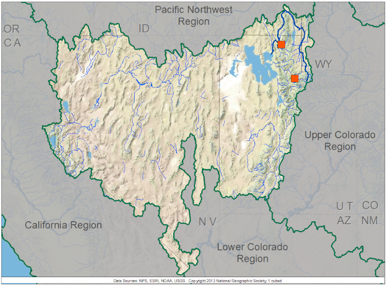
The map below shows the streamflow reconstructions currently available for the Great Basin. Place the cursor on a gage icon to view the gage name, and then click to view the page for that reconstruction, and a link to the data. A list of the reconstructions available for the basin is presented below the map.
Great Basin Reconstructions
One reconstruction of annual/water-year streamflow has been developed for the Great Basin. Those interested in reconstructions for the western Great Basin and Nevada should contact Franco Biondi; for the Wasatch Front and Utah, contact Matthew Bekker.
| Streamflow Reconstruction Page | Period | Data File |
| Logan River | 1605-2010 | Logan |
| Weber River | 1429-2004 | Weber |
Other Hydroclimatic Reconstructions developed for, or including, the Great Basin:
Great Salt Lake Levels, 1429-2005 - DeRose et al., 2014
Annual Precipitation, Northeastern Utah, 1226-2001 - Gray et al. 2004
Nevada Climate Division 3 Annual (July-June) Precipitation - Hughes and Graumlich 1996
Summer (JJA) Palmer Drought Severity Index (PDSI), covering most of North America on 2.5-degree grid
 presents \"Tree-Ring 101\" at the Boulder City, NV workshop.")
Two of our technical workshops for water managers and stakeholders have been held within the Great Basin, or locations immediately adjacent to it. These workshops included presentations relevant to the Great Basin. Click on a workshop below to access a summary report and the presentations; see the Treeflow Workshops page for general information about the workshops.

There are many different ways to use tree-ring reconstructions in the planning and management for water resources, from educational tools to inform stakeholders about the occurrence of severe droughts, to numerical input into water supply models to test the resilience of the system under past hydrologic conditions.
The Southern Nevada Water Authority (SNWA) anticipates using tree-ring data (in the form of precipitation reconstructions in conjunction with groundwater modeling) in a water planning application. Plans for this work were presented by Joseph Leising of SNWA at the Boulder City, NV workshop.
The State of Utah's Drought Plan, revised in 2008, contains a chapter on "Drought from a Paleoclimatic Perspective", based on the gridded summer PDSI reconstructions developed by Cook et al. The quality of the four gridpoint reconstructions within Utah indicates the potential for reconstruction of other hydroclimatic variables, such as annual streamflow.
The TreeFlow Applications page provides summaries of other applications of tree-ring data around the West.
Hydroclimatic reconstructions and analyses
Bekker, Matthew F. R., Justin DeRose, Brendan M. Buckley, Roger K. Kjelgren, and Nathan S. Gill . 2014. A 576-Year Weber River Streamflow Reconstruction from Tree Rings for Water Resource Risk Assessment in the Wasatch Front, Utah. Journal of the American Water Resources Association. doi: 10.1111/jawr.12191
DeRose, R. Justin, Shih-Yu Wang, Brendan M. Buckley, and Matthew F. Bekker. 2014. Tree-ring reconstruction of the level of Great Salt Lake, USA. The Holocene. doi: 10.1177/0959683614530441
Graham, N. E., and M. K. Hughes. 2007. Reconstructing the medieval Mono Lake low stands. The Holocene, 17, 1197-1210
Gray, S.T., S.T Jackson, and J. L. Betancourt. 2004. Tree-ring based reconstructions of interannual to decadal-scale precipitation variability for northeastern Utah since 1226 AD. Journal of the American Water Resources Association 40 (4), 947–960.
Hardman, G. and O.E. Reil. 1936. The Relationship Between Tree Growth and Stream Runoff in the Truckee River Basin. California-Nevada Bulletin 141, Nevada Agricultural Experiment Station. Reno, Nevada.
Hughes, M.K. and G. Funkhouser. 2003. Frequency-dependent climate signal in upper and lower forest border tree rings in the mountains of the Great Basin. Climatic Change 59: 233-244.
Hughes, M. K. and L. J. Graumlich. 1996. Climatic variations and forcing mechanisms of the last 2000 years. Volume 141. Multi-millenial dendroclimatic studies from the western United States. NATO ASI Series, pp. 109-124.
Saito, L., F. Biondi, J.D. Salas, A.K. Panorska, and T.J. Kozubowski. 2008. A watershed modeling approach to streamflow reconstruction from tree-ring records. Environmental Research Letters 3: 024006; doi:10.1088/1748-9326/3/2/024006 (Abstract)
Smith, W.P. 1986. Reconstruction of precipitation in northeastern Nevada using tree rings, 1600-1982. Journal of Climate and Applied Meteorology 25: 1255-1263.
Solander, K., L. Saito, and F. Biondi. 2010. Streamflow simulation using a water-balance model with annually-resolved inputs. Journal of Hydrology 387: 46–53.

